Fichier:Reliefkarte Österreich.png
Aller à la navigation
Aller à la recherche

Taille de cet aperçu : 800 × 445 pixels. Autres résolutions : 320 × 178 pixels | 640 × 356 pixels | 1 024 × 570 pixels | 1 280 × 712 pixels | 3 464 × 1 928 pixels.
Fichier d’origine (3 464 × 1 928 pixels, taille du fichier : 9,42 Mio, type MIME : image/png)
Description
| Description |
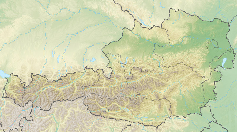
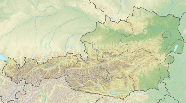
Deutsch: Reliefkarte Österreich
Topographischer Hintergrund: NASA Shuttle Radar Topography Mission (public domain). SRTM3 v.2. |
|||||||||
| Date | ||||||||||
| Source | Travail personnel | |||||||||
| Créé par | ||||||||||
| Autorisation (Réutilisation de ce fichier) |
Moi, en tant que détenteur des droits d’auteur sur cette œuvre, je la publie sous les licences suivantes :
Ce fichier est sous licence Creative Commons Attribution – Partage dans les Mêmes Conditions 2.5 Générique, 2.0 Générique et 1.0 Générique.
Vous pouvez choisir l’une de ces licences. |
|||||||||
| Données géotemporelles | ||||||||||
| Rectangle englobant |
|
|||||||||
| Géoréférencement | ||||||||||

Historique du fichier
Cliquer sur une date et heure pour voir le fichier tel qu'il était à ce moment-là.
| Date et heure | Vignette | Dimensions | Utilisateur | Commentaire | |
|---|---|---|---|---|---|
| Actuel | 8 mai 2018 à 15:53 | | 3 464 × 1 928 (9,42 Mio) | wikimediacommons>Tschubby | == {{int:filedesc}} == {{Information |Description= {{de| Reliefkarte Österreich}} Topographischer Hintergrund: [http://www2.jpl.nasa.gov/srtm NASA Shuttle Radar Topography Mission] (public domain). SRTM3 v.2. |Source={{own}} |Date= 2018-05-08 |Author= Tschubby |Permission= {{self|GFDL|Cc-by-sa-3.0-migrated|Cc-by-sa-2.5,2.0,1.0}} |other_versions= }} Category:Location maps of Austria Category:Topographic maps of Austria |
Utilisation du fichier
Aucune page n’utilise ce fichier.