Fichier:Sumatra Locator Topography.png
Aller à la navigation
Aller à la recherche


Taille de cet aperçu : 559 × 600 pixels. Autres résolutions : 224 × 240 pixels | 447 × 480 pixels | 716 × 768 pixels | 954 × 1 024 pixels | 1 866 × 2 002 pixels.
Fichier d’origine (1 866 × 2 002 pixels, taille du fichier : 2,26 Mio, type MIME : image/png)
Description
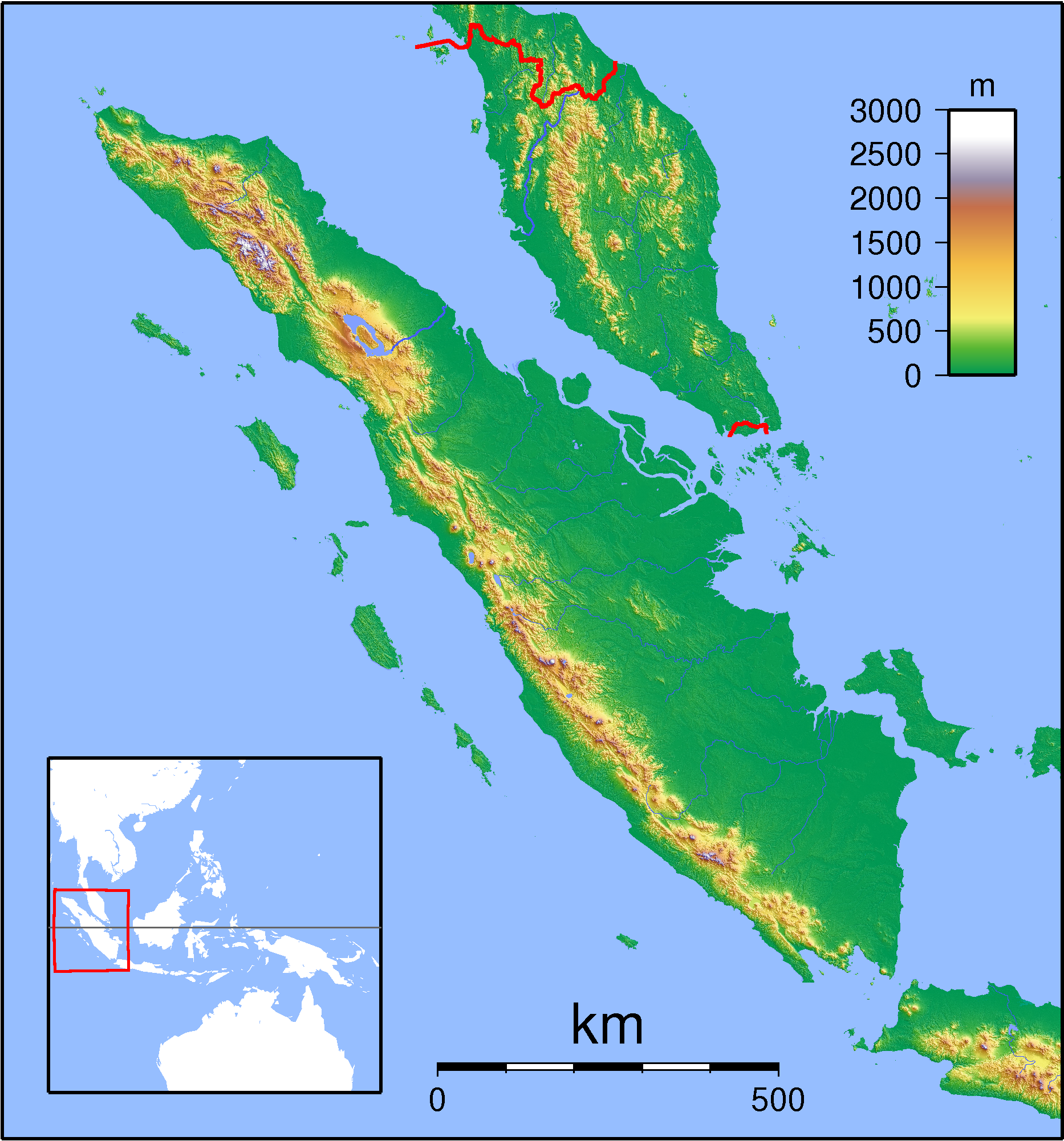
| Description | Topographic locator map of Sumatra. Created with GMT from SRTM data. For non-locator version, see Image:Sumatra Topography.png. Left:94 Bottom:-8 Rght:108 Top:7 |
| Date | |
| Source | Travail personnel |
| Auteur | Sadalmelik |
Conditions d’utilisation
Moi, en tant que détenteur des droits d’auteur sur cette œuvre, je la publie sous les licences suivantes :

|
Vous avez la permission de copier, distribuer et modifier ce document selon les termes de la GNU Free Documentation License version 1.2 ou toute version ultérieure publiée par la Free Software Foundation, sans sections inaltérables, sans texte de première page de couverture et sans texte de dernière page de couverture. Un exemplaire de la licence est inclus dans la section intitulée GNU Free Documentation License. |
Ce fichier est sous licence Creative Commons Attribution – Partage dans les Mêmes Conditions 3.0 (non transposée), 2.5 Générique, 2.0 Générique et 1.0 Générique.
- Vous êtes libre :
- de partager – de copier, distribuer et transmettre cette œuvre
- d’adapter – de modifier cette œuvre
- Sous les conditions suivantes :
- paternité – Vous devez donner les informations appropriées concernant l'auteur, fournir un lien vers la licence et indiquer si des modifications ont été faites. Vous pouvez faire cela par tout moyen raisonnable, mais en aucune façon suggérant que l’auteur vous soutient ou approuve l’utilisation que vous en faites.
- partage à l’identique – Si vous modifiez, transformez, ou vous basez sur cette œuvre, vous devez distribuer votre contribution sous la même licence ou une licence compatible avec celle de l’original.
Vous pouvez choisir l’une de ces licences.
Historique du fichier
Cliquer sur une date et heure pour voir le fichier tel qu'il était à ce moment-là.
| Date et heure | Vignette | Dimensions | Utilisateur | Commentaire | |
|---|---|---|---|---|---|
| Actuel | 1 septembre 2007 à 20:56 | | 1 866 × 2 002 (2,26 Mio) | wikimediacommons>Sadalmelik | {{Information |Description=Topographic locator map of Sumatra. Created with GMT from SRTM data. For non-locator version, see Image:Sumatra Topography.png. Left:94 Bottom:-8 Rght:108 Top:7 |Source=self-made |Date=Sep 1, 2007 |Author= [[User:Sadalmelik |
Utilisation du fichier
Aucune page n’utilise ce fichier.