Fichier:Topography of Ireland.jpg
Aller à la navigation
Aller à la recherche


Taille de cet aperçu : 474 × 600 pixels. Autres résolutions : 190 × 240 pixels | 379 × 480 pixels | 607 × 768 pixels | 809 × 1 024 pixels | 1 618 × 2 048 pixels | 3 293 × 4 168 pixels.
Fichier d’origine (3 293 × 4 168 pixels, taille du fichier : 3,86 Mio, type MIME : image/jpeg)
Description
| Description |
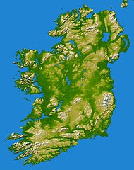
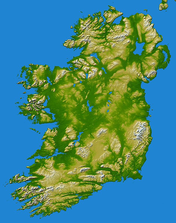
earthobservatory.nasa.gov/IOTD/view.php?id=5343 Elevation data used in this image were acquired by the Shuttle Radar Topography Mission aboard the Space Shuttle Endeavour, launched on Feb. 11, 2000. SRTM used the same radar instrument that comprised the Spaceborne Imaging Radar-C/X-Band Synthetic Aperture Radar (SIR-C/X-SAR) that flew twice on the Space Shuttle Endeavour in 1994. SRTM was designed to collect 3-D measurements of the Earth's surface. To collect the 3-D data, engineers added a 60-meter (approximately 200-foot) mast, installed additional C-band and X-band antennas, and improved tracking and navigation devices. The mission is a cooperative project between NASA, the National Geospatial-Intelligence Agency (NGA) of the U.S. Department of Defense and the German and Italian space agencies. It is managed by NASA's Jet Propulsion Laboratory, Pasadena, Calif., for NASA's Earth Science Enterprise, Washington, D.C.Topography of Ireland - Feb 2000 |
| Date | |
| Source | Flickr |
| Auteur | Danny McL de Whitechapel, London, UK |
| Reviewer | File Upload Bot (Magnus Manske) |
Conditions d’utilisation
Ce fichier est disponible selon les termes de la licence Creative Commons Attribution – Partage dans les Mêmes Conditions 2.0 Générique
- Vous êtes libre :
- de partager – de copier, distribuer et transmettre cette œuvre
- d’adapter – de modifier cette œuvre
- Sous les conditions suivantes :
- paternité – Vous devez donner les informations appropriées concernant l'auteur, fournir un lien vers la licence et indiquer si des modifications ont été faites. Vous pouvez faire cela par tout moyen raisonnable, mais en aucune façon suggérant que l’auteur vous soutient ou approuve l’utilisation que vous en faites.
- partage à l’identique – Si vous modifiez, transformez, ou vous basez sur cette œuvre, vous devez distribuer votre contribution sous la même licence ou une licence compatible avec celle de l’original.
| Cette image, qui provient de Flickr, a été vérifiée le May 31, 2010 par l'administrateur ou l'utilisateur de confiance (trusted user) File Upload Bot (Magnus Manske), qui a confirmé qu'à cette date, elle était publiée sur Flickr sous cette licence. |
Historique du fichier
Cliquer sur une date et heure pour voir le fichier tel qu'il était à ce moment-là.
| Date et heure | Vignette | Dimensions | Utilisateur | Commentaire | |
|---|---|---|---|---|---|
| Actuel | 31 mai 2010 à 09:27 | | 3 293 × 4 168 (3,86 Mio) | wikimediacommons>File Upload Bot (Magnus Manske) | {{Information |Description=[http://earthobservatory.nasa.gov/IOTD/view.php?id=5343 earthobservatory.nasa.gov/IOTD/view.php?id=5343] Elevation data used in this image were acquired by the Shuttle Radar Topography Mission aboard the Space Shuttle Endeavour |
Utilisation du fichier
Les 2 pages suivantes utilisent ce fichier :