Fichier:Athabasca Oil Sands map.png
Aller à la navigation
Aller à la recherche

Taille de cet aperçu : 410 × 599 pixels. Autres résolutions : 164 × 240 pixels | 328 × 480 pixels | 526 × 768 pixels | 1 200 × 1 753 pixels.
Fichier d’origine (1 200 × 1 753 pixels, taille du fichier : 611 kio, type MIME : image/png)
Description
| Description |
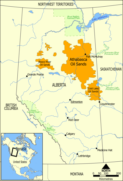
English: This map shows the extent of the oil sands in Alberta, Canada. The three oil sand deposits are known as the Athabasca Oil Sands, the Cold Lake Oil Sands, and the Peace River Oil Sands. |
| Date | |
| Source | Travail personnel |
| Auteur | NormanEinstein |
| Autres versions |
Œuvres dérivées de ce fichier : Athabasca oil sand mining map 2011.jpg: |
Conditions d’utilisation
| Moi, propriétaire des droits d’auteur sur cette œuvre, la place dans le domaine public. Ceci s'applique dans le monde entier. Dans certains pays, ceci peut ne pas être possible ; dans ce cas : J’accorde à toute personne le droit d’utiliser cette œuvre dans n’importe quel but, sans aucune condition, sauf celles requises par la loi. |
Historique du fichier
Cliquer sur une date et heure pour voir le fichier tel qu'il était à ce moment-là.
| Date et heure | Vignette | Dimensions | Utilisateur | Commentaire | |
|---|---|---|---|---|---|
| Actuel | 10 mai 2006 à 18:49 | | 1 200 × 1 753 (611 kio) | wikimediacommons>NormanEinstein | This map shows the extent of the oils sands in Alberta, Canada. The three oil sand deposits are known as the Athabasca Oil Sands, the Cold Lake Oil Sands, and the Peace River Oil Sands. Created by NormanEinstein, May 10, 2006. {{GFDL-self}} [[Category: |
Utilisation du fichier
La page suivante utilise ce fichier :