Fichier:SolarGIS-Solar-map-Peru-en.png
Aller à la navigation
Aller à la recherche


Taille de cet aperçu : 424 × 600 pixels. Autres résolutions : 169 × 240 pixels | 636 × 900 pixels.
Fichier d’origine (636 × 900 pixels, taille du fichier : 447 kio, type MIME : image/png)
Description
| Description |
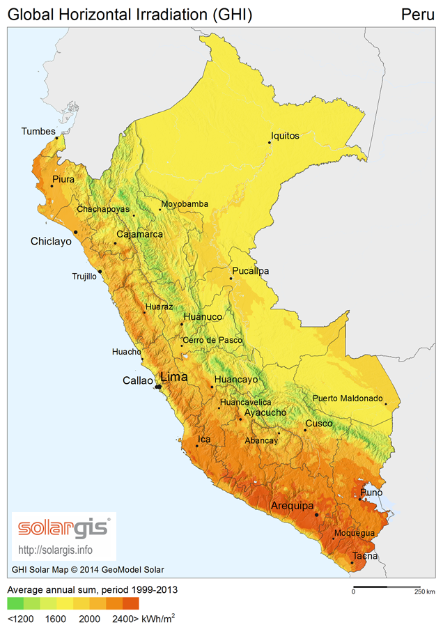
English: Solar Radiation Map: Global Horizontal Irradiation Map of Peru, SolarGIS. English version. |
| Date | |
| Source | Image from free download page |
| Auteur | SolarGIS © 2014 GeoModel Solar |
| Autorisation (Réutilisation de ce fichier) |
The maps are free for public use, their reproduction and adaptation is authorised provided the following source is acknowledged: SolarGIS © 2014 GeoModel Solar By downloading a free map, you acknowledge that GeoModel Solar retains all rights, titles, and interest in the information provided by the maps, including the copyright, SolarGIS logo and all other intellectual property rights, and that GeoModel Solar has the right to make these maps available under Creative Commons Attribution-ShareAlike 3.0 Unported License. GeoModel Solar makes no representations or warranties about the accuracy, reliability, completeness or suitability for any particular purpose of the free maps. You agree that GeoModel Solar is under no liability for any loss or damage (including consequential damage) that you may suffer from the use of the free maps. |
Conditions d’utilisation
Ce fichier est disponible selon les termes de la licence Creative Commons Attribution – Partage dans les Mêmes Conditions 3.0 (non transposée).
Attribution: SolarGIS © 2014 GeoModel Solar
- Vous êtes libre :
- de partager – de copier, distribuer et transmettre cette œuvre
- d’adapter – de modifier cette œuvre
- Sous les conditions suivantes :
- paternité – Vous devez donner les informations appropriées concernant l'auteur, fournir un lien vers la licence et indiquer si des modifications ont été faites. Vous pouvez faire cela par tout moyen raisonnable, mais en aucune façon suggérant que l’auteur vous soutient ou approuve l’utilisation que vous en faites.
- partage à l’identique – Si vous modifiez, transformez, ou vous basez sur cette œuvre, vous devez distribuer votre contribution sous la même licence ou une licence compatible avec celle de l’original.
Historique du fichier
Cliquer sur une date et heure pour voir le fichier tel qu'il était à ce moment-là.
| Date et heure | Vignette | Dimensions | Utilisateur | Commentaire | |
|---|---|---|---|---|---|
| Actuel | 14 mai 2015 à 12:17 | | 636 × 900 (447 kio) | wikimediacommons>Rfassbind | {{Information |Description={{en|1=Solar Radiation Map: Global Horizontal Irradiation Map of Peru, SolarGIS. English version.}} |Source=[http://solargis.info/doc/_pics/freemaps/1000px/ghi/SolarGIS-Solar-map-Peru-en.png Image] from [http://solargis.info/... |
Utilisation du fichier
La page suivante utilise ce fichier :