Fichier:Korea-Gyeongju-Map of mountains and drainage-02.png
Aller à la navigation
Aller à la recherche
Pas de plus haute résolution disponible.
Korea-Gyeongju-Map_of_mountains_and_drainage-02.png (635 × 595 pixels, taille du fichier : 77 kio, type MIME : image/png)
| Description |
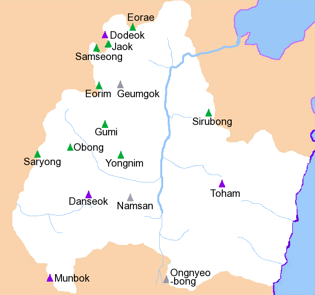
English: Mountains and drainage patterns of Gyeongju City, South Korea. Drawn by hand by User:Visviva. May contain inaccuracies.
한국어: 해발 500미터가 넘는 산은 초록색으로 표시됨.
|
| Date | (UTC) |
| Source | |
| Auteur |
|
| Cette image a été retouchée, ce qui signifie qu'elle a été modifiée par ordinateur et est différente de l'image d'origine. L'image d'origine se trouve ici : Gyeongjumts.png:
|
Moi, en tant que détenteur des droits d’auteur sur cette œuvre, je la publie sous la licence suivante :
| |
Cette image a été (ou est ici-même) mise à disposition dans le domaine public par son auteur, Example dans le projet [[::Main Page| Wikimedia Commons]]. Ceci s'applique partout dans le monde. Au cas où cela n'est pas possible légalement : |
Journal des téléversements d’origine
This image is a derivative work of the following images:
- File:Gyeongjumts.png licensed with PD-user-w
- 2009-09-16T19:29:10Z File Upload Bot (Magnus Manske) 635x595 (63420 Bytes) {{BotMoveToCommons|en.wikipedia|year={{subst:CURRENTYEAR}}|month={{subst:CURRENTMONTHNAME}}|day={{subst:CURRENTDAY}}}} {{Information |Description={{en|Mountains and drainage patterns of [[:en:Gyeongju|]] City, South Korea.
Téléversé avec derivativeFX
Historique du fichier
Cliquer sur une date et heure pour voir le fichier tel qu'il était à ce moment-là.
| Date et heure | Vignette | Dimensions | Utilisateur | Commentaire | |
|---|---|---|---|---|---|
| Actuel | 17 septembre 2009 à 02:31 | | 635 × 595 (77 kio) | wikimediacommons>Caspian blue | {{Information |Description={{en|Mountains and drainage patterns of Gyeongju City, South Korea. Drawn by hand by User:Visviva. May contain inaccuracies. # Mt. Munbok ('Munbok'san'', 1,014m) # Mt Danseok (''Danseoks |
Utilisation du fichier
La page suivante utilise ce fichier :