Garçon devant un ordinateur.jpg
Hollie Little Pink Laptop.jpg
À propos • Aide • Le Livre d'or
Les lecteurs de Vikidia demandent des articles en plus. Voyez la liste d'articles à créer, et venez nous aider à les rédiger !

Fichier:Floridakeys-nasa.jpg

Aller à la navigation Aller à la recherche
Fichier d’origine(1 400 × 1 000 pixels, taille du fichier : 215 kio, type MIME : image/jpeg)

Ce fichier provient de Wikimedia Commons. Il peut être utilisé par d'autres projets. Sa description sur sa page de description est affichée ci-dessous.

Description

Description
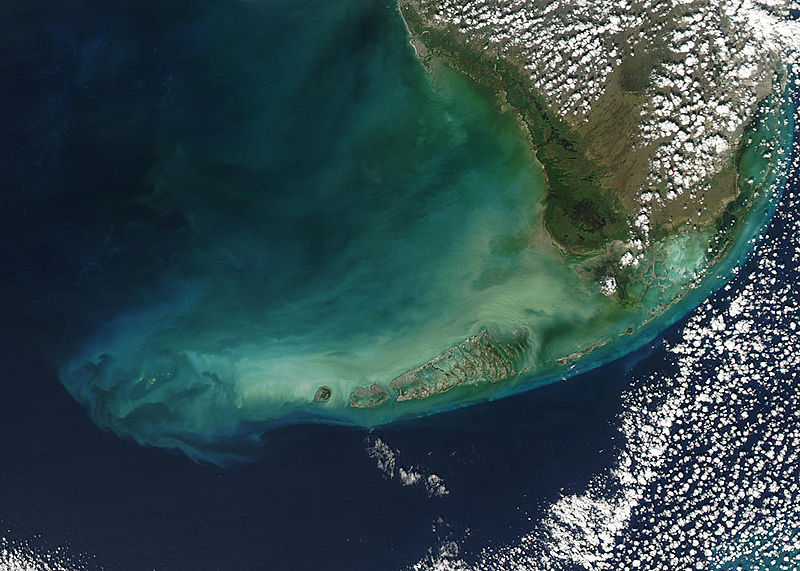
English: Turbid waters surround southern Florida and the Florida Keys in this true-color Moderate Resolution Imaging Spectroradiometer (MODIS) image taken by the Aqua satellite on December 2, 2003. Clouds of milky blue, green, and tan sediments and microscopic marine organisms (like phytoplankton and algae) discolor the water in the Gulf of Mexico north of the Keys, but end abruptly in the deeper water of the Straits of Florida. The water north of the Keys is relatively shallow, so sediments are a likely cause of the discoloration—rough waters can churn up the mud from the sea floor, which then clouds the water. But in the deeper water south of the Keys, sediment on the sea floor is much harder to disturb, which keeps the water clearer.

The Keys are a collection of islands, islets, and reefs stretching from Virginia Key to the Dry Tortugas, a distance of about 309 kilometers (192 miles). They're made mostly of limestone and coral, and are known for their variety of wildlife, subtropical vegetation, and spectacular diving. Most of the islands are connected to the mainland via the Overseas Highway, making this a popular and easily-accessible destination.

However, popularity can be a double-edged sword. On the one hand, tourism is one of the economic mainstays of the region, and helps increase public awareness of how fragile this ecosystem is. But on the other hand, those same tourists and their activities can hurt the ecosystem by introducing pollutants and causing physical damage to fragile reefs.
Date
Source www.nasa.gov
Auteur Jeff Schmaltz, MODIS Rapid Response Team, NASA/GSFC

Conditions d’utilisation

Public domain Ce fichier provient de la NASA. Sauf exception, les documents créés par la NASA ne sont pas soumis à copyright. Pour plus d'informations, voir la politique de copyright de la NASA.
Attention :

Légendes

Ajoutez en une ligne la description de ce que représente ce fichier

Éléments décrits dans ce fichier

dépeint

Historique du fichier

Cliquer sur une date et heure pour voir le fichier tel qu'il était à ce moment-là.

Date et heureVignetteDimensionsUtilisateurCommentaire
Actuel23 août 2005 à 23:59Vignette pour la version du 23 août 2005 à 23:591 400 × 1 000 (215 kio)wikimediacommons>Nanosmile * Credit Jeff Schmaltz, MODIS Rapid Response Team, NASA/GSFC Turbid waters surround southern Florida and the Florida Keys in this true-color Moderate Resolution Imaging Spectroradiometer (MODIS) image taken by the Aqua satellite on Dece

La page suivante utilise ce fichier :