Fichier:Daedongyeojido-full.jpg
Aller à la navigation
Aller à la recherche


Taille de cet aperçu : 356 × 599 pixels. Autres résolutions : 142 × 240 pixels | 285 × 480 pixels | 456 × 768 pixels | 609 × 1 024 pixels | 1 217 × 2 048 pixels | 17 837 × 30 000 pixels.
Fichier d’origine (17 837 × 30 000 pixels, taille du fichier : 99,08 Mio, type MIME : image/jpeg)
Description
| Avertissement | Certains navigateurs peuvent avoir des difficultés à afficher cette image à sa résolution complète : elle possède un nombre de pixels singulièrement élevé et peut ne pas se charger correctement ou faire planter votre navigateur. |
|---|
| Description |
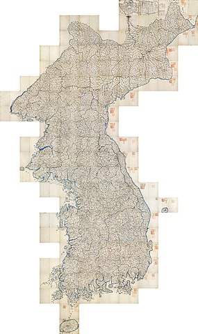
English: Daedongyeojido ("The Great Map of the East Land") is a full scale[Préciser un fait] map of Korea produced in 1861. Although no modern survey techniques were used, it is remarkably similar to modern maps. This marks the zenith of pre-modern Korean cartography; this file is the full mozaic version of it, which can be read just as easily as a Google interactive map. JPG(99 MB) mirror, PNG(618 MB) mirror. All three extant copies of the map are designated as secondary national treasures of South Korea; this one is treasure item number 850-3, which is owned by Seoul National University's Kyujanggak Institute for Korean Studies. Stamps on the map indicate its ownership (""서울 大學校 圖書" for "Seoul National University's book"; "朝鮮総督府圖書之印" for "stamp of Governor-General of Korea"; and "奎章閣韓國學圖書" for Kyujanggak Institute for Korean Studies. See discussion of stamps here.
한국어: 《대동여지도》(大東輿地圖)는 1861년에 김정호가 제작한 한국의 고지도이다. 근대적 측량 기술이 사용되지 않았으나, 그 세밀함이 근대의 지도에 필적한다. 전근대 한국 지도제작술의 정수라고 할 수 있다.
العربية: هذه الخريطة القديمة صنعها كم جونغ هو، وتعرف باسم دايدونغ يوجيدو وحرفياً "الخريطة العظمى للأراضي الشرقية" (بالكورية: 대동여지도) وتمثل أفضل أعمال كم. رسمت الخريطة في سنة 1861، في زمن مملكة جوسون. صنعت الخريطة باستخدام الأساليب الكورية والغربية، وتعتبر خريطة متقدمة بالنسبة لزمن صنعها. |
| Date | |
| Source | http://147.46.103.182/OIS/GZ2/VIEWER.jsp?maptype=DD001 |
| Créé par | |
| Géoréférencement | Si c'est inapproprié, définissez warp_status = skip pour masquer. |
| Autres versions |

|

Cette image a été choisie comme image du jour pour le 9 août 2013. La description associée était la suivante : English: Daedongyeojido ("The Great Map of the East Land") is an old map of Korea, which was made in 1861. Although no modern survey skills were used for this map, it is almost similar to modern maps. Autres langues :
Deutsch: Daedongyeojido ("Die große Karte des östlichen Landes") ist eine alte Karte von Korea aus dem Jahr 1861. Obwohl keine modernen Techniken zu ihrer Herstellung verwendet wurden, sind die Unterschiede zu heutigen Karten minimal. English: Daedongyeojido ("The Great Map of the East Land") is an old map of Korea, which was made in 1861. Although no modern survey skills were used for this map, it is almost similar to modern maps. Italiano: Daedongyeojido ("La grande mappa della Terra Orientale") è una vecchia mappa della Corea realizzata nel 1861. Sebbene non siano state usate le moderne tecniche topografiche per la sua realizzazione è molto simile alle mappe moderne. Magyar: Daedongyeojido ("A keleti ország nagy térképe") Korea 1861-ben készült térképe. Bár nem használtak hozzá modern felméréseket, a mai térképekkel közel azonos Nederlands: Daedongyeojido ("De grote kaart van het Oostland") is een oude kaart van Korea die gemaakt werd in 1861. Hoewel er geen moderne opmetingstechnieken werden toegepast voor de kaart, is deze sterk gelijkend ten opzichte van moderne kaarten. Русский: Карта Кореи 1861 года. 日本語: 『大東輿地図』(だいとうよちず)は、金正浩が1861年に完成した韓国の古地図である。近代的測量技術が使われなかったが、その細密さが近代の地図に匹敵する。 中文: 大東輿地圖,绘制于1861年,虽然没有运用现代的技术,但是已经很接近现代的地图。 |
Conditions d’utilisation
|
Ceci est une reproduction photographique fidèle d'une œuvre d'art originale en deux dimensions. L'œuvre d'art elle-même est dans le domaine public pour la raison suivante :
La position officielle de la Fondation Wikimedia est que « les représentations fidèles des œuvres d'art du domaine public en deux dimensions sont dans le domaine public et les exigences contraires sont une attaque contre le concept même de domaine public ». Pour plus de détails, voir Commons:Quand utiliser le bandeau PD-Art.
Cette reproduction photographique est donc également considérée comme étant élevée dans le domaine public. Merci de noter qu'en fonction des lois locales, la réutilisation de ce contenu peut être interdite ou restreinte dans votre juridiction. Voyez Commons:Reuse of PD-Art photographs. | ||||
| Annotations | Cette image est annotée : Voir les annotations sur Wikimedia Commons |
Cette image a été promue au rang d'image de qualité d'après les critères du Guide des images.
|
Historique du fichier
Cliquer sur une date et heure pour voir le fichier tel qu'il était à ce moment-là.
| Date et heure | Vignette | Dimensions | Utilisateur | Commentaire | |
|---|---|---|---|---|---|
| Actuel | 5 février 2013 à 03:11 | | 17 837 × 30 000 (99,08 Mio) | wikimediacommons>Salamander724 | non-progressive |
Utilisation du fichier
La page suivante utilise ce fichier :