Fichier:USA Territorial Growth small.gif
Aller à la navigation
Aller à la recherche
Pas de plus haute résolution disponible.
USA_Territorial_Growth_small.gif (431 × 287 pixels, taille du fichier : 456 kio, type MIME : image/gif, en boucle, 10 trames, 30 s)

|
Ce fichier a été remplacé par File:USA territorial growth.gif. Il est recommandé d’utiliser l’autre fichier. La suppression des fichiers remplacés requiert un accord.
|

|
Description
| Description |
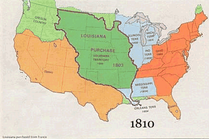
English: US territorial growth 1810–1920, based on the PD USGS maps in Category:Territorial growth maps of the United States.
See key below for explanation of colors.  |
||||||
| Source |
|
||||||
| Auteur |
|
||||||
| Autres versions |
|
Conditions d’utilisation
Cette image est placée dans le domaine public parce qu'elle contient des éléments issus de l'United States Geological Survey, une agence du Département de l'Intérieur des États-Unis. Pour plus d'information, consultez la politique officielle de copyright de l'USGS (en anglais)
|
Historique du fichier
Cliquer sur une date et heure pour voir le fichier tel qu'il était à ce moment-là.
| Date et heure | Vignette | Dimensions | Utilisateur | Commentaire | |
|---|---|---|---|---|---|
| Actuel | 30 mai 2006 à 12:50 | | 431 × 287 (456 kio) | wikimediacommons>Roke~commonswiki | US territorial growth, based on the PD USGS maps in Category:USA Territorial Growth Maps Category: USA Territorial Growth Maps {{PD-USGov-USGS}} |
Utilisation du fichier
Les 4 pages suivantes utilisent ce fichier :